UHICast
Predict. Prepare. Protect.
Problem & Motivation
In recent months, cities worldwide have faced unprecedented heatwaves, worsening the impact of urban heat islands (UHIs). For instance, in April 2024, temperatures in Southeast Asia exceeded 40°C (104°F) for several days. This extreme heat is part of a troubling trend driven by climate change and rapid urbanization. Urban areas, with their dense buildings and heat-absorbing surfaces, are significantly warmer than rural areas. This urban heat island effect raises city temperatures by several degrees, exacerbating heat waves and leading to higher energy consumption, air pollution, and health issues.
Despite the clear dangers, many cities lack effective tools to monitor and respond to areas at risk. Traditional methods are manual, labor-intensive, and not widely accessible, highlighting the urgent need for advanced technology. More importantly, these solutions primarily provide snapshots of current or past conditions. UHICast addresses this with a swift and economical solution using machine learning and satellite imagery. UHICast enhances the accuracy of identifying current and future high-risk heat areas by forecasting land surface temperatures. This enables urban planners and government officials to allocate resources more effectively and mitigate risks. Moreover, by identifying areas of extreme heat, UHICast enables cities to better manage power grid loads during peak demand periods. This allows for more efficient energy distribution, reducing the risk of blackouts and ensuring a stable power supply during critical times.
Data Source & Data Science Approach
This study utilizes satellite-based remote sensing data from Landsat 8 along with weather sensor data to analyze and predict land surface temperature (LST). The data processing steps include cloud masking, atmospheric correction, and the calculation of various spectral indices such as NDVI and NDBI. Additionally, ground-based weather observations are integrated to enrich the dataset. The study employs a comprehensive benchmarking framework that includes traditional statistical models, regression models, and advanced deep-learning architectures to predict LST intensity at multiple time horizons (up to 10 days).
Evaluation
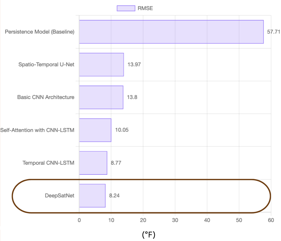
The performance of the models is evaluated using a range of error metrics including Mean Absolute Error (MAE), Root Mean Square Error (RMSE), and Nash-Sutcliffe Efficiency (NSE). As the image above shows, DeepSatNet achieved the lowest RMSE at 8.24°F, demonstrating its accuracy in predicting Land Surface Temperature (LST). Our evaluation spanned various seasonal periods and urban contexts, focusing on each model's ability to capture complex temporal and spatial patterns over the past year. Beyond accuracy, we also considered model interpretability and practical utility, ensuring these tools are effective for real-world urban planning and decision-making.
Key Learnings
The UHI effect is a pressing global issue where urban areas experience elevated temperatures due to human activities and environmental changes. This intensifies the impact of heatwaves, especially in densely populated cities, making accurate forecasting and effective resource allocation essential. The study highlights that deep learning models relatively excel in analyzing LST and UHI dynamics. Specifically, using models like DeepSatNet, shows great promise for improving LST prediction. However, predicting land surface temperature (LST) is particularly challenging in regions with frequent cloud cover. The reliance on satellite and weather data, along with the need to fill gaps caused by cloudiness, can introduce errors. Furthermore, managing large-scale, high-resolution (30-meter) spatio-temporal data demands significant infrastructure. The rapid increase in data volume highlights the need for scalable solutions to effectively process and manage this data.
Impact
Urban Planners and Government officials: UHICast’s LST forecasting can significantly support urban planners and government officials in identifying high-risk heat areas, enabling more effective resource allocation, such as setting up cooling centers and implementing public health interventions during extreme heat events.
Energy Management: Energy companies can utilize UHICast’s forecasts to optimize energy distribution, particularly during peak demand periods triggered by heatwaves. This can help prevent blackouts and alleviate stress on energy grids.
Global Impact: UHICast assists global efforts to prepare for and mitigate the impacts of climate change, equipping urban areas with the insights needed to protect communities and infrastructure.
Acknowledgments
This research was supported by datasets from the Landsat program, the Google Earth Engine platform, and the Weatherbit API. A big thank you to our amazing instructors, Kira Wetzel and Puya Vahabi, and to all our collaborators for their invaluable guidance and support!
*The UHICast project logo was created using Canva


